
North Dakota facts often surprise students: a river that flows north, a garden shared with Canada, and wide prairie land where wheat fields and wind turbines stretch to the horizon. Yet on the first day of a state study, many fourth graders can only say that North Dakota is “cold and far away.” The facts are interesting, but without a plan they blur together.
This guide turns that state study into a five-step mini course. By the end, you will be able to organize North Dakota facts by region, teach the symbols, explore the land and rivers, connect cities to the economy, and check what students really remember.
Examples are fictional. Adapt them to your students and your state standards.
At a glance
- Sort facts into three land regions from east to west.
- Teach each symbol with a short reason students can retell.
- Use the Red River, the badlands, and the Peace Garden as anchors.
- Link cities and land to the work people do: farming, oil, and wind energy.
- Check learning with short daily tasks, then reteach the gaps.
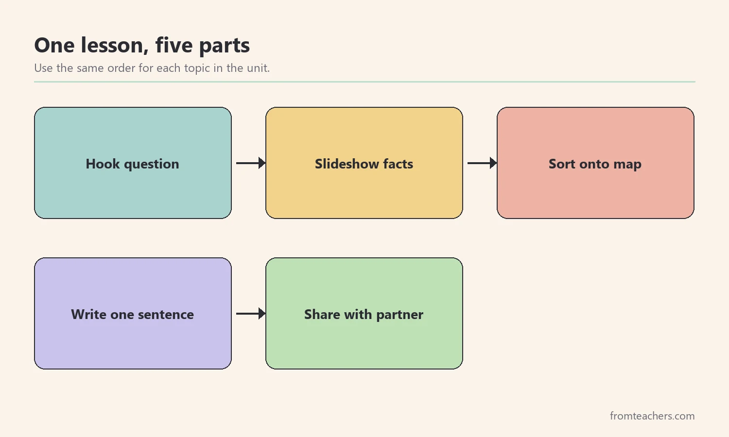
1. Organize North Dakota facts into three regions
First, give students a simple map frame. North Dakota is often described in three land regions: the Red River Valley in the east, the Drift Prairie in the middle, and the Missouri Plateau, part of the Great Plains, in the west. When every new fact has a region, students remember it more easily.
Next, draw the state outline and divide it into three parts from east to west. Then ask the same three questions for each region: What does the land look like? What do people do there? What is one famous place? These questions guide the whole unit.
Also, point out the big idea early. Much of North Dakota is flat or gently rolling prairie, which is excellent for farming and wide open spaces. However, the west also has the rugged badlands. That contrast helps students see that one state can hold very different landscapes.
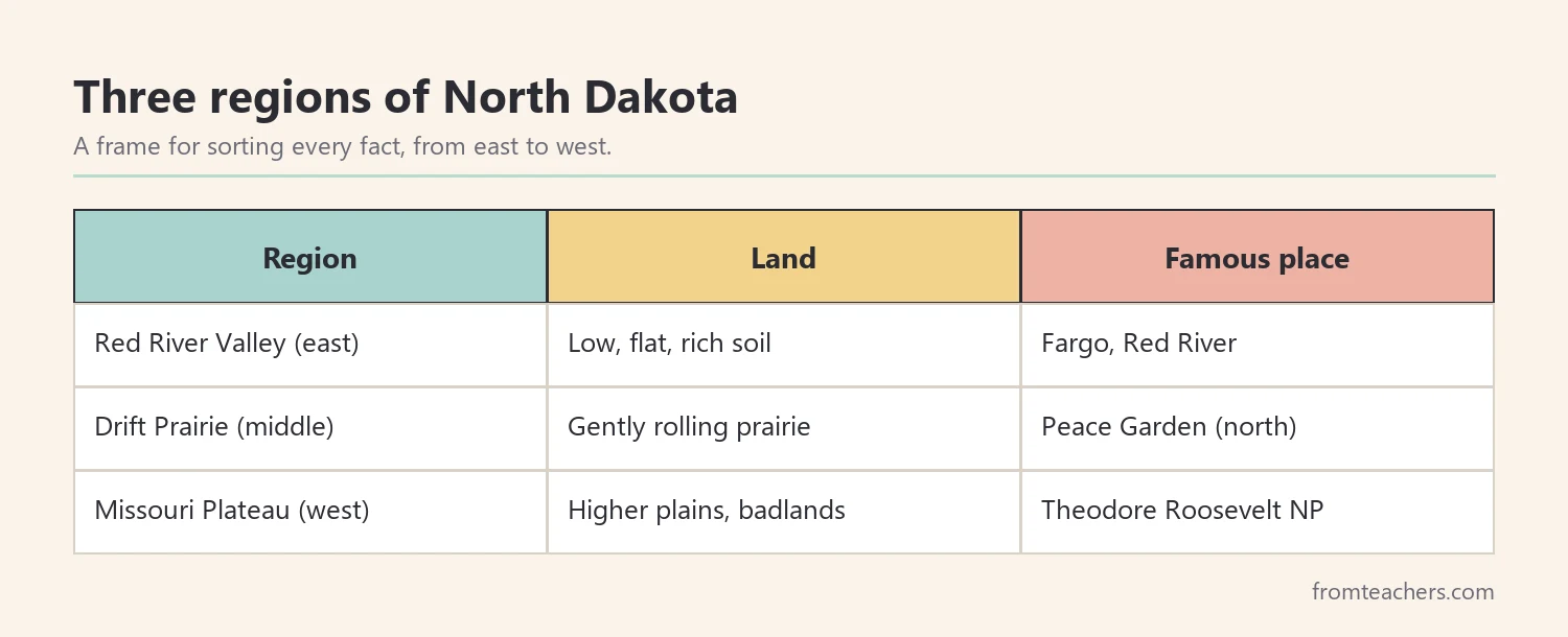
Worked example. Ms. Ortiz teaches a fictional grade 4 class of 26 students. On Monday, she tapes a large outline of the state to the board and divides it into three parts. Ava, one of her students, asks why the east is called a valley. Ms. Ortiz explains that it is low, flat land along the Red River. Ava writes “valley, prairie, plateau” in her notebook.
Before moving on, give each student a three-column organizer labeled Red River Valley, Drift Prairie, and Missouri Plateau. Throughout the unit, students add new North Dakota facts to the right column. By the end, the organizer becomes a personal study guide.
In short, a three-region frame turns scattered North Dakota facts into an organized map. As a result, every later lesson has a place to land.
2. Teach the state symbols with a story
Next, introduce the symbols. However, a list of names is easy to forget. Instead, give each symbol a short “why” that students can say in their own words.
For example, North Dakota is called the Peace Garden State. The name comes from the International Peace Garden, which sits on the border between North Dakota and Canada and celebrates friendship between the two countries. The capital is Bismarck, on the Missouri River. The state tree is the American elm, a tall shade tree often planted along town streets, and the state bird is the western meadowlark.
| Symbol | North Dakota | A hook for students |
|---|---|---|
| Nickname | Peace Garden State | A garden shared with Canada |
| Capital | Bismarck | Find it on the Missouri River |
| State tree | American elm | A shade tree on town streets |
| State bird | Western meadowlark | A singing bird of the prairie |
Then, let students make a symbol card for each one: a picture, the name, and one sentence about why it matters. In addition, ask them to place the card on the regions map. The Peace Garden card, for instance, goes on the northern border.
A ready-made North Dakota state study slideshow with facts, symbols, and landmarks can carry this part of the lesson. It includes a title slide with the state shape, flag, wheat, and river, a state tree slide on the American elm, and a closing slide that reviews the key symbols.
Worked example. Ava’s group makes four symbol cards. When Ms. Ortiz asks where the nickname comes from, Ava says, “From a peace garden on the border with Canada.” She places the card at the top of the map.
To close the lesson, add one fun fact: North Dakota has 53 counties, and many of them are rural and agricultural. Ask students to guess why a farming state might have so many small, spread-out communities, then connect their answers back to the prairie.
3. Explore the land and rivers behind North Dakota facts
Then, bring the map to life with places students can picture. Once a student can see a place in their mind, the North Dakota facts linked to it are easier to recall.
Start with the Red River of the North. It forms much of the border with Minnesota, and, unlike most rivers students know, it flows north toward Canada. A quick demonstration helps: tilt a tray of sand slightly, pour water at the higher end, and show that water always flows downhill. Then explain that the land along the Red River slopes down toward the north.
Next, move west to the Missouri River, which crosses the state and flows past Bismarck. Ask students to find both rivers on the map and compare their directions.
Finally, visit the badlands in the west. Theodore Roosevelt National Park protects colorful, rugged hills and wildlife such as bison. Show a photo next to a photo of a flat wheat field and ask students to describe the difference in three words each.
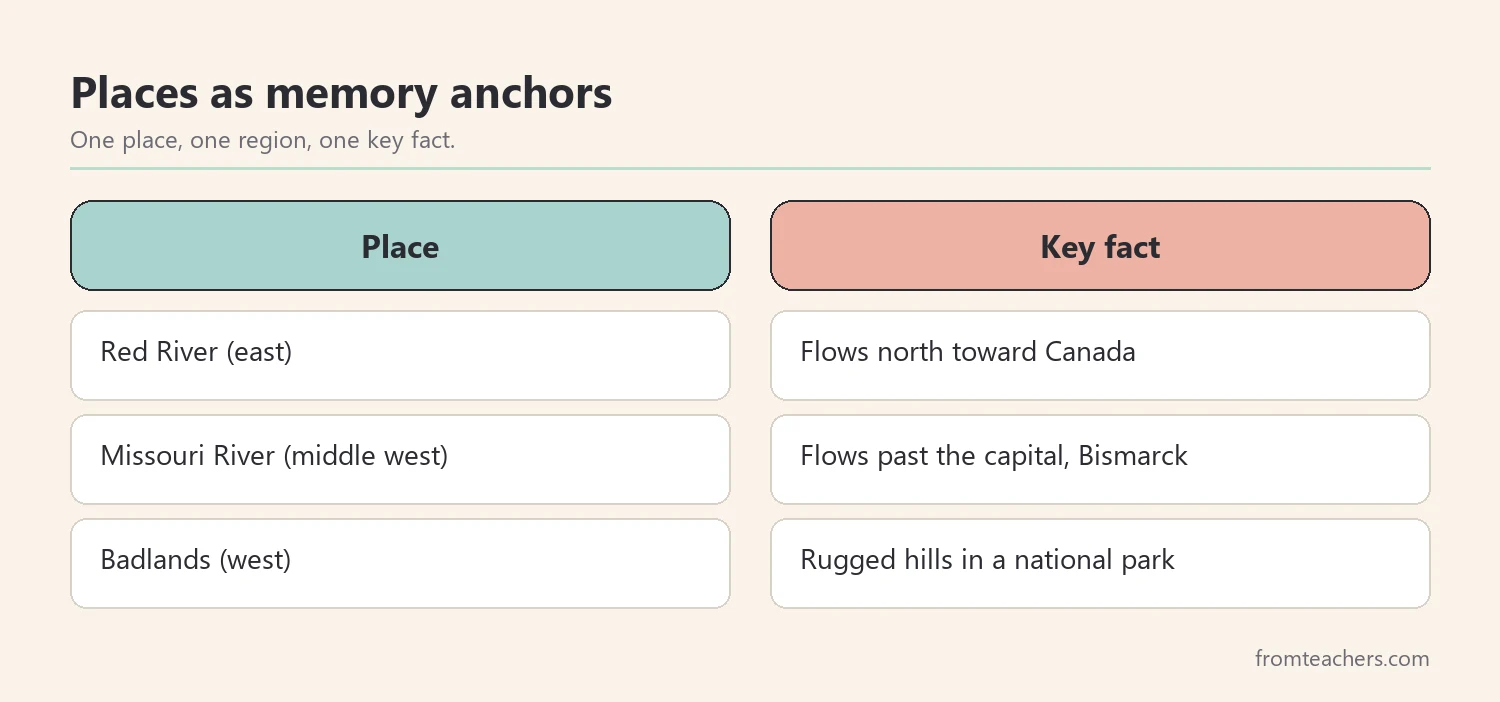
Because these stories are vivid, students can mix them up. So, after each place, ask students to say the place, the region, and one of the North Dakota facts linked to it in one sentence, such as “The Red River is in the east and flows north.”
Worked example. Ava pours water on the tilted sand tray and watches it run “north.” She writes, “The Red River flows north because the land slopes down that way.” That one sentence links a river, a region, and a reason.
4. Connect North Dakota facts about cities to the economy
Now, connect places to people. Students remember cities better when they know what people do there. So, pair each place with one kind of work.
For example, Fargo is the largest city in the state, with roughly 125,000 people, and it sits in the Red River Valley. Bismarck is the capital, where state government meets. Grand Forks is another city in the valley, and Minot is a trade center in the north central part of the state. Across the state, farming is a major part of life, especially wheat. In the west, oil is produced in the Bakken Formation, and steady prairie winds power wind turbines.
| Place | Region | Work linked to it |
|---|---|---|
| Fargo | Red River Valley | Largest city, trade and services |
| Bismarck | Missouri River area | State government |
| Prairie farms | Valley and prairie | Wheat and other crops |
| Bakken area | West | Oil production |
| Open plains | Across the state | Wind energy |
Then, run a quick “job match” activity to practice these North Dakota facts. Write jobs on cards, such as farmer, oil worker, wind technician, and state lawmaker. Students place each card where it fits best and explain their choice to a partner.
In addition, make a paper pinwheel to show how wind turns a turbine. Students blow on it softly and then hard, and notice the difference. This links a fact about wind energy to something they can feel.
Worked example. Ava places “wind technician” on the open plains and “oil worker” in the west. When her partner asks why, she says, “The Bakken is in the west, and the wind blows across the flat land.” Her answer shows she is connecting North Dakota facts, not just repeating them.
5. Check and review what students remember
Finally, check learning with short, frequent tasks. A long test at the end tells you what students forgot, but a quick daily check tells you what to reteach tomorrow.
For example, use a five-question exit ticket after each lesson. Ask one question about regions, one about a symbol, one about a river or landmark, one about a city or job, and one “why” question. Then, count correct answers and reteach the weakest area the next morning.
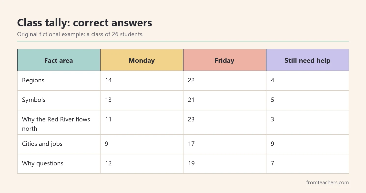
Worked example. On Monday, 11 of Ms. Ortiz’s 26 students can explain why the Red River flows north, so 15 cannot yet. By Friday, after the sand tray demonstration and two reviews, 23 can, and only 3 still need help. The tally also shows that cities and jobs remain the weakest area, so she adds one more job match game.
Also, keep the checks low-stress. Students can answer on mini whiteboards or hold up region cards. When students know that mistakes help you plan, they share what they really think about North Dakota facts.
In addition, end the unit with a small project. Students can make a postcard from the badlands to a friend in Fargo, or a “North Dakota in a bag” with one object per region, such as wheat, a toy bison, and a paper pinwheel.
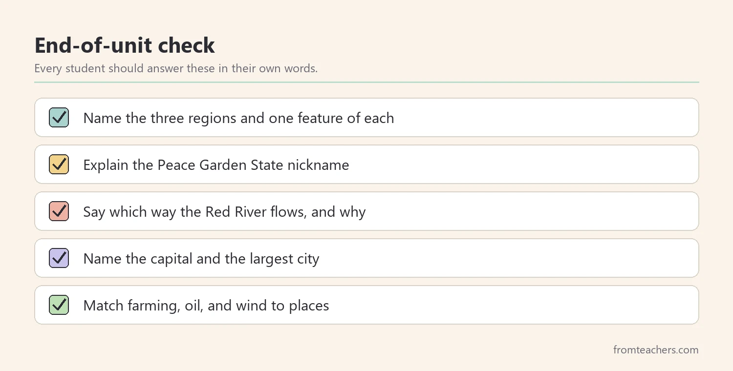
In short, small checks guide your teaching. Therefore, students leave the unit with North Dakota facts they can explain, not just recite.
Common mistakes and how to avoid them
Even a well planned unit on North Dakota facts can drift. Here are common problems and simple fixes.
- Teaching facts as one long list. Fix: sort every fact into a region first.
- Naming symbols without a reason. Fix: give each symbol a one-sentence story.
- Saying “the river flows north” without showing why. Fix: use a tilted sand tray to show water flowing downhill.
- Using numbers students cannot picture. Fix: compare city sizes to a town or city students know.
- Treating the state as only flat farmland. Fix: show the badlands next to the prairie.
- Waiting until the end to check learning. Fix: use a short exit ticket after each lesson.
Questions teachers and parents ask about North Dakota facts
What grade level is best for North Dakota facts?
Many schools study states in grades 3 to 5, and these activities fit that range well. Younger students can focus on the regions map and symbol cards. Older students can add more detail on rivers and the economy.
What are the most important North Dakota facts for kids?
Start with the capital (Bismarck), the nickname (Peace Garden State), the three land regions, the north-flowing Red River, and the main kinds of work: farming, oil, and wind energy. These give students a strong base.
How long should a state study take?
A focused unit fits into one or two weeks of short daily lessons. Follow the five steps in order and add a small project at the end if time allows.
How can parents help at home?
Parents can look at a map together and ask which region a place is in. Even a short conversation about North Dakota facts helps students retell what they learned.
How do I support students who struggle to remember facts?
Keep the three-region frame visible, use pictures for every fact, and repeat key words often. In addition, let these students work with a partner during sorts and give them a word bank with key place names.
Related reading: 5 Practical Teaching Tips to Boost Classroom Focus and Learning and Learning Styles Student Success Guide.
A companion resource for your North Dakota state study
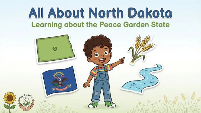
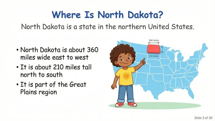
North Dakota State Study: Facts, Symbols, and Famous Landmarks: a colorful “All About North Dakota” slideshow covering major cities, the American elm, the plains, the economy, and a fun fact slide, made for elementary state studies.
Sources and scope
- ND.gov: the official website of the State of North Dakota.
- State Historical Society of North Dakota: history, symbols, and educational materials about the state.
- National Park Service: information on national parks, including Theodore Roosevelt National Park.
- U.S. Census Bureau: official population data for states and cities.
- National Council for the Social Studies: guidance for teaching social studies in K-12 classrooms.
This guide offers a classroom approach to teaching North Dakota facts in the upper elementary grades. It does not cover the full history of the state, and population figures change over time, so check current numbers before you teach them.
Key takeaways
- Sort North Dakota facts into three regions so every fact has a home.
- Give each symbol a short story, like the Peace Garden on the Canada border.
- Use the Red River, the Missouri River, and the badlands as memory anchors.
- Link places to work: wheat farming, Bakken oil, and wind energy.
- Check learning daily with short exit tickets and reteach the gaps.








Leave a Comment