
North Carolina facts can feel like a long list to memorize: a capital, a state tree, a nickname, a famous flight, and a coastline that stretches for miles. Picture a fourth grade class on day one of a state study. The students can repeat that the Wright brothers flew there, but they cannot say where, why it mattered, or how the beaches connect to the mountains.
This guide turns that list into a five-step mini course. By the end, you will be able to organize North Carolina facts into big ideas, teach the state symbols, explore landmarks, connect cities to the economy, and check what students really remember.
Examples are fictional. Adapt them to your students and your state standards.
At a glance
- Group facts under three regions: mountains, Piedmont, and coastal plain.
- Teach symbols with a story behind each one, not just a name.
- Use landmarks like the Outer Banks and the first flight site as anchors.
- Link each major city to the work people do there.
- Check learning with short sorts and quizzes, then review the gaps.
1. Organize North Carolina facts into three regions
First, give students a mental map before you give them details. North Carolina is usually taught as three regions: the mountains in the west, the Piedmont in the middle, and the coastal plain in the east. When every new fact has a “home” region, it is much easier to remember.
Next, show a simple outline map and color each region with students. Then ask one question per region: What does the land look like? What do people do there? What is one famous place? These three questions become the frame for the whole unit.
Also, introduce the big contrast early. One of the most memorable North Carolina facts is that the state has both high mountains and long sandy beaches. In fact, it is possible to visit both in the same day if you start early and drive across the state. Students love this detail, and it sets up the regions perfectly.
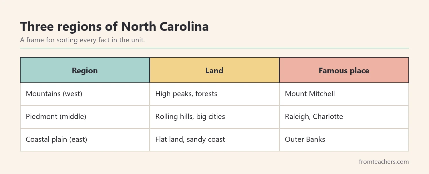
Worked example. Ms. Lane teaches a fictional grade 4 class of 24 students. On Monday, she draws the three regions on chart paper. Leo, one of her students, asks why the mountains are in the west. She points to the map and explains that the land rises from the coast toward the mountains in the west. Leo writes “beach, middle, mountains” in his notebook.
Before moving on, give each student a blank three-column organizer labeled Mountains, Piedmont, and Coastal plain. Throughout the unit, they add new North Carolina facts to the right column. By the last day, the organizer becomes a personal study guide that students can take home and explain to a family member.
In short, a three-region frame turns scattered North Carolina facts into an organized map. As a result, every later lesson has a place to land.
2. Teach the state symbols with a story
Next, introduce the symbols. However, avoid a flat list. Instead, give each symbol a short “why” that students can retell.
For example, North Carolina is called the Tar Heel State. The state tree is the longleaf pine, a tall tree whose sap was historically used to make tar and pitch. That connection helps students link the nickname and the tree. The capital is Raleigh, in the Piedmont region, and the state bird is the cardinal.
| Symbol | North Carolina | A hook for students |
|---|---|---|
| Nickname | Tar Heel State | Connect it to tar from pine trees |
| Capital | Raleigh | Find it in the Piedmont region |
| State tree | Longleaf pine | Tall pines used for tar and pitch |
| State bird | Northern cardinal | Look for the bright red bird |
Then, let students make a symbol card for each one: a picture, the name, and one sentence about why it matters. In addition, ask them to place each card on the regions map. The longleaf pine, for instance, is strongly tied to the coastal plain.
A ready-made North Carolina state study slideshow with facts, symbols, and landmarks can carry this part of the lesson. It includes a title slide with the state shape and flag, a state tree slide on the longleaf pine, and a closing slide that reviews the key symbols.
Worked example. Leo’s group makes four symbol cards. When Ms. Lane asks why the state is called the Tar Heel State, Leo answers, “Because of tar from the pine trees.” He places the pine card on the coastal plain.
3. Explore landmarks that anchor North Carolina facts
Then, bring the map to life with landmarks. Landmarks work as “anchors” because students can picture them. Once a student can picture a place, the North Carolina facts connected to it are easier to recall.
Start with the Outer Banks, a chain of narrow barrier islands that stretches about 200 miles along the coast. Explain that barrier islands help protect the mainland from storms and waves. A simple demonstration helps: build a sand “coast” in a tray, add a strip of sand in front as an island, and pour water to show how the island takes the force first.
Next, tell the story of the first flight. In December 1903, Wilbur and Orville Wright made the first successful powered airplane flights near Kitty Hawk, on the Outer Banks. Strong, steady winds and soft sand made the area a good place to test their flyer. Students can fold paper gliders and test them, then write one sentence on why the brothers chose this spot.
Because these stories are vivid, they are also easy to mix up. So, after each landmark, ask students to say the landmark, the region, and one of the North Carolina facts linked to it in a single sentence, such as “The Outer Banks are on the coast and protect the mainland from storms.”
Finally, head west to the mountains. Mount Mitchell, in the Blue Ridge area, is the highest peak east of the Mississippi River. Pair it with a photo and ask students to compare the land there with the sandy coast.
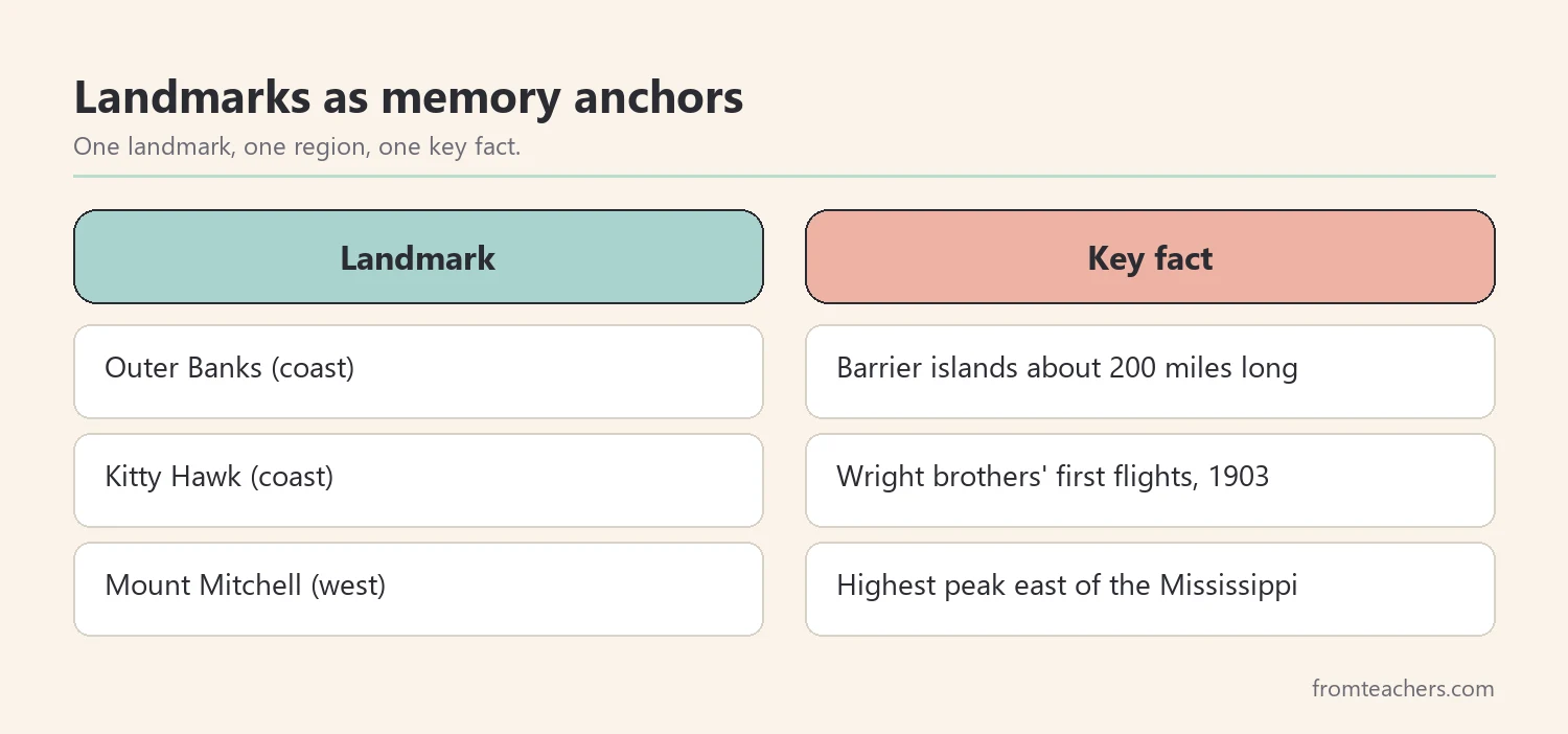
Worked example. Leo’s paper glider flies farthest when the classroom fan is on. He writes, “The Wright brothers picked Kitty Hawk because it had strong wind and soft sand for landing.” That one sentence links a landmark, a region, and a reason.
4. Connect North Carolina facts about cities to the economy
Now, connect places to people. Students remember cities better when they know what people do there. So, pair each city with one kind of work.
For example, Charlotte is the largest city in the state, with roughly 900,000 people, and it is known as a major banking center. Raleigh is the capital, where state government meets. Durham is known for education and research, and Greensboro is another large city in the Piedmont. In addition, farming matters across the state, with crops like sweet potatoes and tobacco, and tourism brings visitors to both the beaches and the mountains.
| Place | Region | Work linked to it |
|---|---|---|
| Charlotte | Piedmont | Banking |
| Raleigh | Piedmont | State government |
| Durham | Piedmont | Education and research |
| Coastal plain farms | Coastal plain | Sweet potatoes, tobacco |
| Beaches and mountains | Coast and west | Tourism |
Then, run a quick “job match” activity to practice these North Carolina facts. Write jobs on cards, such as bank teller, farmer, scientist, park ranger, and hotel worker. Students place each card on the region where it fits best and explain their choice to a partner.
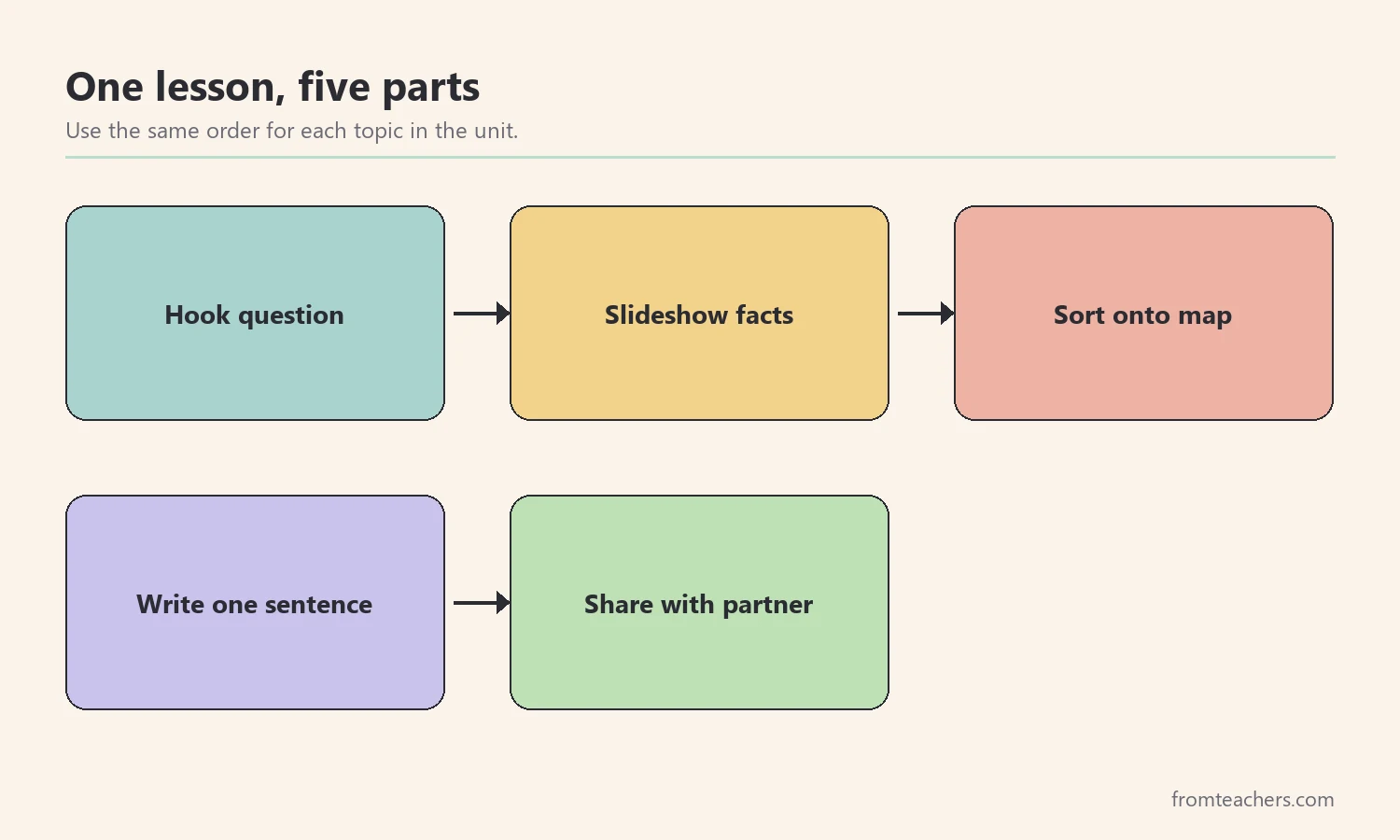
Worked example. Leo places “farmer” on the coastal plain and “scientist” near Durham. When his partner asks why, he says, “Durham has universities and research.” His explanation shows he is connecting North Carolina facts, not just repeating them.
Overall, linking cities to work gives facts a purpose. As a result, students start to see the state as a real place where people live.
5. Check and review what students remember
Finally, check learning with short, frequent tasks. A long test at the end of the unit tells you what students forgot, but a short check each day tells you what to reteach tomorrow.
For example, use a five-question exit ticket after each lesson. Ask one question about regions, one about a symbol, one about a landmark, one about a city, and one “why” question. Then, count how many students answer each question correctly and reteach the weakest one the next morning.
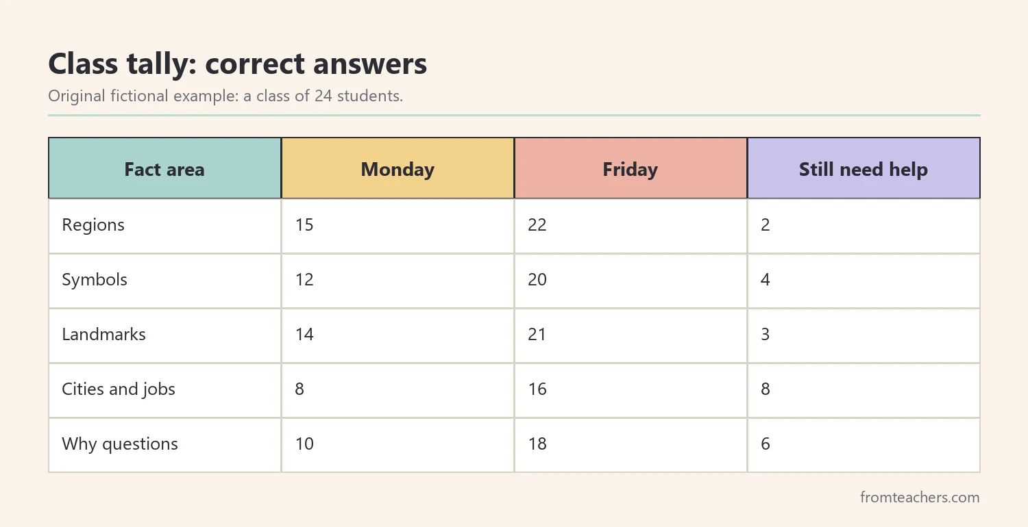
Worked example. On Monday, 15 of Ms. Lane’s 24 students can name all three regions, so 9 cannot yet. By Friday, after two short reviews, 22 can, and only 2 still need help. The tally also shows that city and job matches are the weakest area, so she adds one more job match game the following week.
Also, keep the checks low-stress. Students can answer on mini whiteboards, hold up region cards, or give a thumbs up or down. The goal is information for you, not a grade. When students know that mistakes help you plan the next lesson, they share what they really think about North Carolina facts.
In addition, finish the unit with a small project. Students can make a “North Carolina in a bag” with three objects, one per region, and explain each object. Alternatively, they can write a short travel postcard from the Outer Banks to a friend in the mountains.
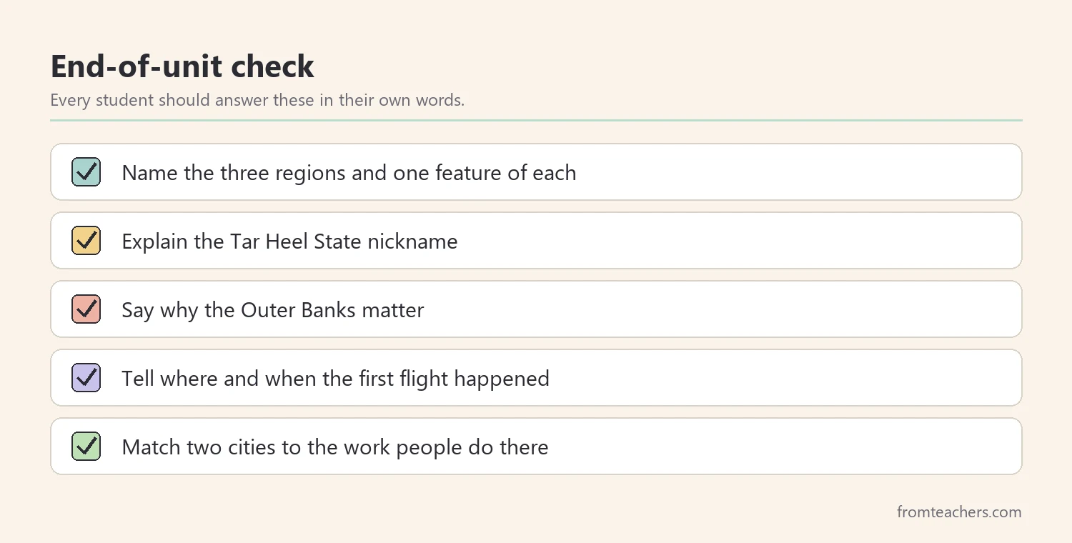
In short, small checks guide your teaching. Therefore, students leave the unit with North Carolina facts they can explain, not just recite.
Common mistakes and how to avoid them
- Teaching facts as one long list. Fix: sort every fact into a region first.
- Naming symbols without a reason. Fix: give each symbol a one-sentence story.
- Telling the first flight story without a place. Fix: always point to Kitty Hawk on the map.
- Using numbers students cannot picture. Fix: compare city sizes or distances to something local.
- Treating North Carolina facts as separate from other subjects. Fix: connect them to reading, writing, and science, such as wind and flight.
- Waiting until the end to check learning. Fix: use a short exit ticket after each lesson.
Questions teachers and parents ask about North Carolina facts
What grade level is best for North Carolina facts?
Many schools study states in grades 3 to 5. The activities in this guide fit that range well. Younger students can do the regions map and symbol cards, and older students can add more detail on the economy.
What are the most important North Carolina facts for kids?
Start with the capital (Raleigh), the nickname (Tar Heel State), the three regions, the Outer Banks, and the Wright brothers’ first flight near Kitty Hawk. These give students a strong base for any further study.
How long should a state study take?
A focused unit can fit into one or two weeks of short daily lessons. Use the five steps in order and add a small project at the end if time allows.
How can parents help at home?
Parents can look at a map together, ask “which region is that in?”, and share a family memory of any trip. Even a short conversation about North Carolina facts helps students retell what they learned.
How do I support students who struggle to remember facts?
Keep the three-region frame visible, use pictures for every fact, and repeat key words often. Short, daily reviews work better than one long review before a test. In addition, let these students work with a partner during sorts, and give them a word bank with the key place names so they can focus on meaning rather than spelling.
Related reading: 5 Practical Teaching Tips to Boost Classroom Focus and Learning and Learning Styles Student Success Guide.
A companion resource for your North Carolina state study
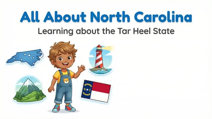
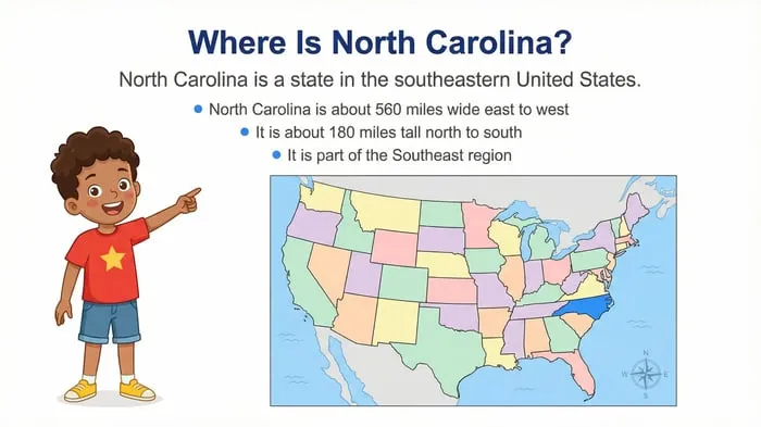
North Carolina State Study: Facts, Symbols, and Famous Landmarks: a colorful “All About North Carolina” slideshow covering major cities, the longleaf pine, the Outer Banks, the economy, and a fun fact slide, made for elementary state studies.
Sources and scope
- NCpedia, State Library of North Carolina: an online encyclopedia of North Carolina history, geography, and symbols.
- NC.gov: the official website of the State of North Carolina.
- National Park Service: information on national parks and memorials, including sites on the Outer Banks.
- U.S. Census Bureau: official population data for states and cities.
- National Council for the Social Studies: guidance for teaching social studies in K-12 classrooms.
This guide offers a classroom approach to teaching North Carolina facts in the upper elementary grades. It does not cover the full history of the state, and population figures change over time, so check current numbers before you teach them.
Key takeaways
- Sort North Carolina facts into three regions so every fact has a home.
- Give each state symbol a short story students can retell.
- Use the Outer Banks, Kitty Hawk, and Mount Mitchell as memory anchors.
- Link cities like Charlotte, Raleigh, and Durham to the work people do there.
- Check learning daily with short exit tickets and reteach the gaps.








Leave a Comment